
The Bridges
Back to the HOME page:
Until the 19th century, no bridges existed over rivers at Millhouse. There were fords through the Caldew & Gilcambon for the horse drawn vehicles, but as you can imagine, these would be completely unusable through periods of heavy rainfall.
A timber foot bridge was constructed over the Gilcambon on the footpath route, (which at that time was spanned over the river just within what is now the caravan site) to enable the post man to make his deliveries via Deer Rudding & Haltcliffe Bridge, which were all done on foot.
A timber foot bridge was constructed over the Gilcambon on the footpath route, (which at that time was spanned over the river just within what is now the caravan site) to enable the post man to make his deliveries via Deer Rudding & Haltcliffe Bridge, which were all done on foot.
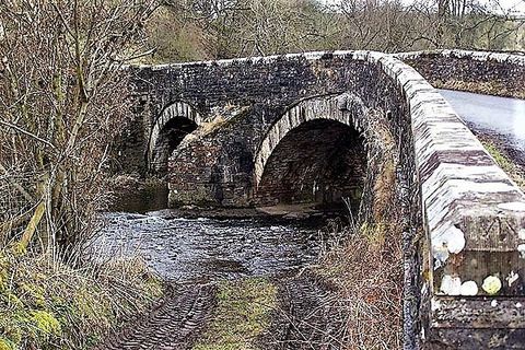
The major construction of the single arch bridge over the Caldew was carried out during the late 1800’s.
A sophisticated hardwood structure had to be made to support the stones for forming the arch during construction.
It was only when the final key stones had been put in place that the timber structure could be dismantled.
Please note: the debris clinging to the upper tree branches indicate the depth of storm Desmond was in fact up to the key stone of the bridge.

The work was carried out by the Builder William Dixon, with a small army of manual labourers and specialist craftsmen, many of them local. The year of completion: 1896

Since the
MILLHOUSE
bridge construction, there have been many negative remarks about its short sighted planning and design.
As with post experience, its river flow capacity should have been much, much larger, and that not enough preliminary research into the river’s characteristics were carried out, and that it should have been designed and built with a much wider span,
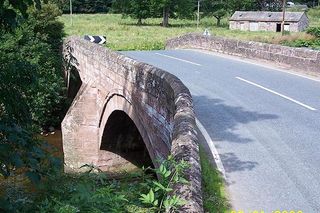
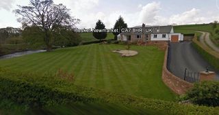
or as a double arch similar to Hesket Newmarket,
(shown here).
(And unlike ours, the Hesket Newmarket bridge
still has it's originally designed credible natural overflow/by-pass path)

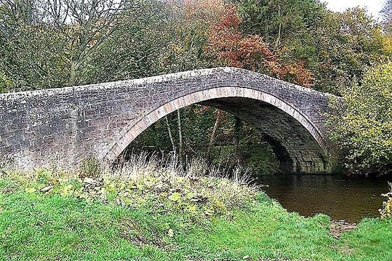
Sebergham bridge,
(shown here) also has two arches. Each of the arches have a similar capacity to our solitary single arch at MILLHOUSE.
Sebergham bridge
also still has it's originally designed natural overflow/by-pass.
The Bridge at Rose Castle,
(shown here) also spans the river Caldew, also has 2 arches and an overflow by-pass route.

MILLHOUSE
bridge, shown below:
has been built with just a solitary arch, which struggles to cope with the river in full spate during periods of extreme relentless rainfall, and is now deprived of any credible form of overflow/by-pass.

(a) Even though there are tributary becks feeding into the Caldew between MILLHOUSE
and Sebergham,
the major catchment area of the Caldew is the wide expanse of the Northern Fells.
(b) During relentless rainfall MILLHOUSE
bridge has to accommodate the full brunt volume of the Northern Fells catchment area just the same as Hesket Newmarket, Sebergham & Rose Castle.
(c) The expanding river volume is rapidly accentuated when relentless rain falls onto melting ice and snow on the Northern Fells.
(d) Sadly the MILLHOUSE
bridge capacity is just not designed for these extreme times.
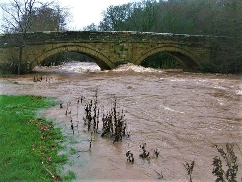
When a bridge reaches the stage when it can’t cope with the extra water volume of a river in full spate, it takes on a new role and name, “a dam”.
There is very little doubt that because of the bridge minimal flow capacity during extreme relentless rainfall, it has contributed to some of the most horrendous historic flooding events that MILLHOUSE
has endured following its construction, BUT
there are no records of flooding of MILLHOUSE,
from the river, prior to the bridge construction.
Most ancient arched bridges were designed with an overflow path, as was MILLHOUSE
bridge, as indicated by the arrows.
This is a Google Earth image dated 2003, before the construction of a modern structure which now blocks the vital overflow route.
This is a Google Earth image dated 2003, before the construction of a modern structure which now blocks the vital overflow route.

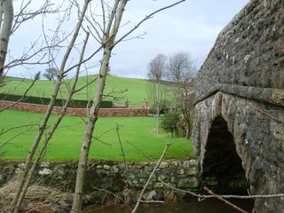
The modern structure lacks a vital integrated facility in it's design to maintain the original bridge overflow-path for extreme flood water volumes experienced prior to, and during the reintroduction of river flooding in 2005,
also the proceeding events in 2009, 2012 & 2015.
T.C.Bell C.Eng MiMaTEST. A historian / expert on ancient bridges, and retired civil engineer, has written many local history books featuring ancient structures and ground workings including bridges, has kindly given his time to do a complimentary survey of our bridge, which confirmed that the vital original overflow/by-pass route has in fact been blocked.
T.C.Bell C.Eng MiMaTEST. A historian / expert on ancient bridges, and retired civil engineer, has written many local history books featuring ancient structures and ground workings including bridges, has kindly given his time to do a complimentary survey of our bridge, which confirmed that the vital original overflow/by-pass route has in fact been blocked.

Sadly, the 120 year old bridge, is now deprived from its originally designed flood plane overflow/by-pass path, which has been recently inadvertently obstructed by a modern structure.
Unfortunately, these recent actions have now reintroduced the vulnerable homes of MILLHOUSE to an extreme risk to flooding,
Jan. 2005, Nov. 2009, June 2012 & Dec. 2015.
Unfortunately, these recent actions have now reintroduced the vulnerable homes of MILLHOUSE to an extreme risk to flooding,
Jan. 2005, Nov. 2009, June 2012 & Dec. 2015.
We've seen the result of the overwhelmed "Bell Bridge" (between Sebergham & Welton) which collapsed during storm Desmond.

(a) Now with the deprivation of the original overflow/by-pass path, when the arch of MILLHOUSE
bridge becomes overwhelmed, it launches a rapid multiplying funnelling/stacking effect.
(b) As well as the inducement of the Caldew to overtop the main village defence bank, this stacking effect was clearly evident as far back up-steam as the Gilcambon Beck during the crescendo of storm Desmond and the 3 previous events.
(c) The tremendous weight and uplifting effect of the stacked water behind the overwhelmed MILLHOUSE
bridge arch presents a serious threat to the 120 year old structure.
6 homes, and 6 family's lives were devastated in MILLHOUSE, on the 5th December 2015 by flood water from the river Caldew, due to the overwhelmed bridge.
A sizeable obstruction wall, (of non-local stone)
and raised level drive has been inadvertently built across the originally designed overflow/by-pass route, with a result of creating biased priority for the river to overflow the defence bank to the mercy of the village.

In simple terms, "THE TOP OF THE OBSTRUCTION (WALL) has been constructed in such a way that it EQUALS THE LEVEL OF THE TOP OF THE VILLAGE FLOOD DEFENCE BANK", and capable of holding back a depth of nearly 5ft of overflowing river water from its original escape route to the lower lying flood plain field.
The obstruction wall, (of non-local stone)
NOW INDUCES MULTIPLE STACKING, leading to the OVERTOPPING of the village DEFENCE BANK for almost its entire length. The wall was apparently CONSTRUCTED WITHOUT ANY FORMAL NOTIFICATION, APPLICATION, CONSENSUAL PLANNING/ENVIRONMENTAL PERMISSION, from any local authority.
"The installers have been publicly adament that their wall is not causing a problem, and have strenuously argued, despite the villagers plea's, that it should remain in place in its current form for their own reminiscence, nostalgic and cosmetic reasons,
and request that the flood victims of MILLHOUSE, together with the E.A. should now find alternatives to sort the reintroduced repetitive flooding problem to innocent people's homes of MILLHOUSE".
And if you are pinning your hopes on the recently installed experimental micro slot in the preliminary wall by the Environment Agency, think again,
as realistically it is miles from being man-enough to cope with the sizable river overflow/stacking as experienced during the 3 previous flooding events.
It is half-heartedly already almost blocked by the vigorous growth of the shrubs behind it. And because of it's minute size and minimal flow capacity, realistically its intended function is certain to be overwhelmed and blocked by floating tree branches and associated debris within the first few moments of the river bursting it's bank.
The overflowing river used to flow freely across the road into the low lying field as a surface torrent at this point.


The land owners have been blatantly adamant, (for self preservation and cosmetic reasons), (audio record) that they would NOT allow a (crucial) larger bypass provision in this preliminary wall, OR , their later wall/raised drive, (built during 2003-04), which would have undone their created inadvertent blockage of the bridge overflow bypass route.
Instead they requested that the victims, and the E.A. seek alternative flood preventive methods for MILLHOUSE.
Please Mr Lawton @ the Environment Agency, you really do need to waken up to reality, to the fact of the sheer enormity of the huge overflow volume induced by the funnelling/stacking of the overwhelmed bridge during these extreme storm times, and before the next one.
The sooner the original overflow/by-pass route for the river Caldew bridge is reinstated, the sooner the properties in MILLHOUSE
will actually become desirable and marketable, (as they used to be).
_______________________________________________________
The road
bridge over the Gilcambon Beck
was built in much recent times with modern concrete and steel construction techniques.
The original timber footbridge was situated slightly downstream from the current one.
The original timber footbridge was situated slightly downstream from the current one.
Funded by the parish council, the current footbridge
was built by local tradesmen in the 1940's, (the same time as the Gillcambon road bridge) using the steel chassis members of a horse drawn timber wagon, (previously used by the sawmill) positioned 15” apart and filled with concrete, then ¾” galvanised water pipe, supported on 12 cranked 2" vertical angle iron brackets, added as hand rails.

