
Details of the reintroduced Flooding History of MILLHOUSE,
2005 to 2015.

The very simple but realistic historic facts are:
The west bank field downstream from the bridge has provided an idealistic overflow floodplain path for the overwhelmed bridge for more than a century, since it's construction.

This overflow feature was purposely integrated into the design and construction of the bridge, (which was completed in 1896), and also the design of the flood defence bank in the 1960's
For more about the history, plus the negative characteristics of MILLHOUSE
bridge, visit "the Bridges" page. https://www.millhouse-hesketnewmarket.com/the-bridges
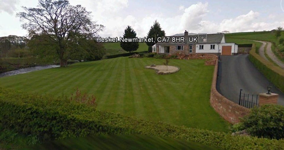
This vital overflow function is now inadvertently deprived by a 5ft garden wall and raised level drive, which has terminated the original essential provision.
The modern structure lacks a vital integrated facility in it's design to maintain the intended original bridge overflow-path for extreme river water volumes which can not
be termed as a recent arrival by so-called global warming,
as realistically, these periods of extreme relentless rainfall have been a regular phenomenon since time began. And paramountly since the bridge construction, (1886) the hamlet of
MILLHOUSE
has suffered many many flooding events due the bridge's low capacity and funneling effect, (but before the placement of the flood defence bank in the early 1970's, and then after the above shown wall and raised drive was built in 2003/04).
Rivers are natural water courses, self-formed hundreds/thousands/millions of years before the advent of "man" and their modern structures. Modern "Man" has a natural instinct to build. Sadly, man made structures now infringe into the natural path and overflow paths of many, many rivers drastically reducing their original natural aperture, and full spate flow path.
Cockermouth & Carlisle would probably still be flood free if the natural original water courses had not been abused and modified by "man". Many original natural flood plains are now saturated by man made structures which now deprive the water from it's overflowing coarse and original natural accommodative route/size.
Sadly the Environment & local authority officials are just sitting back to grant size compaction and potential abuse to natural water courses, allowing this serious phenomenon to escalate.
During extreme storms, the overwhelmed low capacity MILLHOUSE
bridge triggers a funnelling effect which, (now deprived of it's original overflow path) causes the river Caldew to stack, multiplying to new unprecendented levels, which was very evident on the upstream land and upper reaches of the flood defence bank during the 2005, event, ("first time" flowing around it's upper end) then the 2009 & 2012 events, but actually overtopping the flood defence bank in huge volume for almost it's entire length during the crescendo of storm "Desmond" on 5th December 2015.
The defence bank was built in the 1960's. From then, until 2005, stacked river water was "never" experienced on the land upstream beyond the top end of the flood defence bank. The obstruction wall was built, (2003-04) just prior to the January 2005 flood event. Thats a period of over 40 years flood free for MILLHOUSE. The river just "never" stacked high enough during extreme storm times, to come anywhere close to flow around the top end of the main flood defence bank.
Soon after the 2005 event, a private survey was carried out by "Tweddle & Slater", funded by Lyne & Simon Smith, who lived in the Mill at that time. The survey revealed that much higher abnormally stacked river levels had been experienced further back upstream during the January 2005 event.
Tweddle & Slater's resultant recommendation was that action was needed to prevent the unprecedented stacked river water from flowing down the rear of the defence bank.
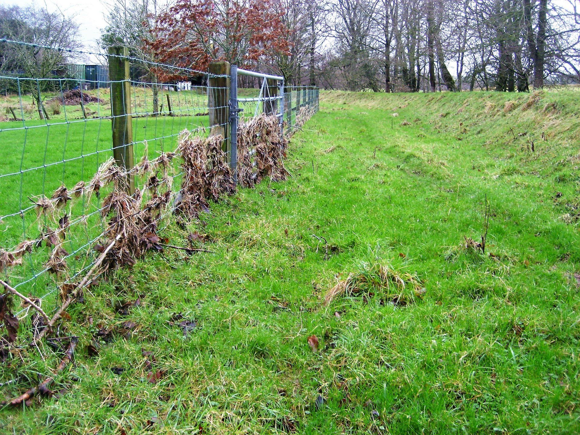
The construction of a 90deg. bank and reinforced galvanized flood gate was then promptly instigated and funded by the Caravan park owners.

This 90 deg bank, & Gate performed perfectly during the stacked river levels in 2009.
However the 50mtr upper end of the main E.A. flood defence bank in Mrs Malaband's field overtopped on this occasion to flow down into the village. This was pointed out to Mrs Malaband, and she instigated and funded the 50mtr upper end to be heightened by half a meter.
However, during the crescendo of the 2012 event, the stacking of the river rose to a new unprecendented level, enough to flow around the upper end of the 90deg. bank, down the drive past Rose Garth into the village.

Immediately after the 2012 event, the installation of a 2ft high humpty-back in the private road was instigated, to prevent a reoccurrence.
The privately constructed 90deg bank, gate and humpty-back in the road performed perfectly during storm Desmond in Dec.2015.
But during the crescendo of storm Desmond in December 2015, the river stacked to new higher levels than ever, and as demostrated on this website, the main flood defence bank overtopped in huge volume for almost it's entire length, lagooning the village within 10 to 15 minutes, to the height of the top of the obstruction wall, cross referenced with the key stone of the bridge arch, also matching the levels experienced in victims homes, and a village bench-mark of the front door step of "Sunlea".
A great deal of unnecessary private funding and effort has had to be voluntary injected into quite projects upstream, (namely the 90deg Bank). These private projects have been carried out just to compensate by providing additional essential resilience for the village from the newly experienced higher level upstream stacking of the river, which undoubtably is now being caused by the overwhelmed bridge, now deprived of its original overflow path.
___________________________________________________________
"Public and formal notice to the Environment Agency"
Dated 26th November 2017
The owners of the upstream land from the upper end of the E.A. Defence bank, (the Caravan Park) so far, (over the past decade) have had no alternative but to carryout multiple projects to compensate for the ne unprecedented river stacking phenomenom, (on a voluntary basis to defend the village), inadvertantly triggered by others, by their instigation of an unregulated project adjacent the bridge.
Sadly, the E.A., the M.F.A.G. and some of the villagers have, and still are being unjustly hoodwinked to believe very dishonest totally fabricated versions of events, by others solely interested in their own cosmetic and nostalgic self preservation.
The owners of the upstream land were actually used as scapegoats, being very unjustly and falsely labled with a margin of blame after one of the flooding events, by one or more of the flood victims.
The said landowners have constantly made repeated attempts to the Environment Agency to impress this factual new unprecedented river stacking phenomenon. The E.A. have responded negatively to date, choosing to completely ignore the realistic facts, hoodwinked to believe the very fabricated reported versions.
Therefore, the said land owners now wish to formally give notice that they are no longer prepaired to support and maintain this on-going progression at their own expense, until such times that the E.A. credibly change their current attitude, and focus their attention towards the true epicentre & reintroduced route cause of the newly experienced increased levels of river stacking, caused by the overwhelmed bridge, and to fully reinstate the infrastructure to its former essential sustainable function.
Nor are they prepared to allow access on their land by any E.A. or M.F.A.G official without formal prior arrangement. Permission will "never be granted" to the E.A. to carry out any work on this land until the issue of the low capacity bridge and purposely designed original overflow path is credibly and sustainably rectified/reinstated.
The said land owners wish to make it clear that they are no longer prepared to be taken for granted. Their swift actions and dedication has saved the village from certain flooding disasters on many occasions, a routine which has been completely taken for granted by others, (even villagers).
They state they will no longer feel compelled to carry-out upgrades on their property, due to the fault of others, therefore will not be held responsible for any future flooding event, (perhaps the next event) which may occur proceeding their withdrawal of their dedicated intensive support which has been provided for the welfare of the villagers for more than a decade.
To date, the said land owners have receaved absolutely no credible recognition from the Environment Agency, the M.F.A.G., even villagers, for their dedication & extreme efforts.
Sadly, the E.A. and some villagers have been dishonestly hoodwinked to believe other fabricated accounts of how the flooding events of the past decade unfolded.
It is now high time for the Environment Agency to get their act together, and soon.
Meanwhile, please don't rely on us during the next extreme storm this winter, until the low capacity bridge has a sustainable and credible overflow route to the "orriginal, and only flood plain". Any Alternative will NOT be enough.
Until then, (as they would say on Dragons Den) "We're Out"
__________________
The sooner the original overflow/by-pass for the river Caldew bridge is reinstated, the sooner the properties in MILLHOUSE
will actually become desirable and marketable, (as they used to be).
Sadly, another flooding event and more hardship may have to be experienced before the-powers-that-be individuals are completely convinced about the very realistic and proven facts laid out on the pages of this website.